
Attractions in Mount Elgon National Park
Mount Elgon offers much more than a summit. The route rises through montane forest, bamboo, heath and Afro-alpine moorland before reaching the caldera rim. Caves, waterfalls, cliffs, pools and volcanic formations appear across both sides of the mountain. Some well-known sites, including Kitum Cave and Endebess Bluff, are inside Kenya’s Mount Elgon National Park and require Kenyan entry arrangements.
Mount Elgon Caldera, Wagagai Peak and the High Mountain
The caldera dominates the summit area. It covers about 40 square kilometres and measures roughly 8 kilometres across, with high points rising around its broken rim. Wagagai stands at 4,321 metres, the highest point on Mount Elgon and the main summit for treks from Uganda. Mubiyi rises to about 4,210 metres, while Jackson’s Peak reaches 4,165 metres. Koitoboss, at 4,222 metres, lies on the Kenyan side. Above 3,500 metres, open moorland replaces the forest and bamboo. Giant lobelias, groundsels, rocky valleys and volcanic ridges fill the approach to the summit. Hot springs near the caldera and the Suam Gorge add another feature to the upper mountain. Reaching Wagagai is the main goal for many hikers, but the caldera crossing and changing vegetation are the most challenging parts of the trek.
Mount Elgon Caves and the Elephant Caves
Mount Elgon contains caves formed within layers of volcanic rock. Kitum Cave, the best-known elephant cave, lies inside Kenya’s Mount Elgon National Park and extends about 200 metres into the mountain. Elephants enter the cave to scrape mineral-rich salts from the walls. Making’eny Cave, also on the Kenyan side, has a waterfall over its entrance. Chepnyalil, Ngwarisha and Kiptoro are among the other caves reached from the Kenyan park. On the Ugandan side, forest walks around Kapkwai reach caves and waterfalls on the lower slopes, while Hunters Cave and Mude Cave serve as points on longer mountain routes. Choose the correct park entrance for the cave you want to visit. A Sipi or Kapkwai itinerary does not provide direct access to Kitum Cave without crossing into Kenya and entering through the Kenyan side.
Jackson’s Pool and Jackson’s Peak
Jackson’s Pool lies at about 4,050 metres beside the Sasa Trail. Jackson’s Peak rises above it to 4,165 metres as a free-standing volcanic plug. Both are named after Frederick Jackson, who explored the summit area in 1889. The shallow pool sits in open moorland and provides a clear marker on the approach to the caldera. Local traditions also connect the area with ancestral life. Cold wind, mist and rapid weather changes are common at this altitude, so keep warm layers and rain protection accessible even when the lower slopes are clear.
Mount Elgon Forests Moorlands and Plant Life
The lower park slopes carry dense montane forest up to about 2,500 metres. Olive, Elgon teak, Podocarpus, vines, mosses and epiphytes grow in this zone. Bamboo and mixed low-canopy forest dominate from roughly 2,500 to 3,000 metres. Giant heather becomes prominent between 3,000 and 3,500 metres. Above 3,500 metres, the vegetation opens into Afro-alpine moorland dotted with giant lobelias and groundsels. A multi-day trek passes through each zone, making the change in plant life one of the mountain’s defining experiences. The lower forest feels enclosed and humid, while the summit plateau is exposed, cold and open.
Wildlife and Birdlife in Mount Elgon
Elephants and buffalo live in Mount Elgon’s forests but are rarely seen along the main trekking routes. Bushbuck, duikers, Defassa waterbuck, bush pigs, tree hyrax, blue monkeys and black-and-white colobus also occur here. Leopards, servals and spotted hyenas remain secretive. More than 300 bird species occupy the forest, heath and moorland. Key birds include Jackson’s francolin, Hartlaub’s turaco, black-collared apalis, African blue flycatcher, African goshawk, Tacazze sunbird and the lammergeier or bearded vulture. Walk quietly through the forest, pause near flowering plants and listen before moving on. Different altitude zones produce different sightings, so a longer trek gives birders a broader range than a single lower-slope walk.
Sipi Falls
Sipi Falls lies immediately outside the Ugandan national park and works well as a base before or after a trek. The Sipi River drops over three basalt cliffs along a scenic 7-kilometre section of the valley. The main waterfall descends about 100 metres, and guided walks connect it with the other two falls through farms, villages and steep valley paths. Sipi is about an hour from Mbale under normal road conditions. Waterfall walks, Arabica coffee tours, rock climbing and mountain biking can fill a day or two around the summit trek. Travellers without time for a multi-day climb can still experience the lower Mount Elgon scenery from Sipi.
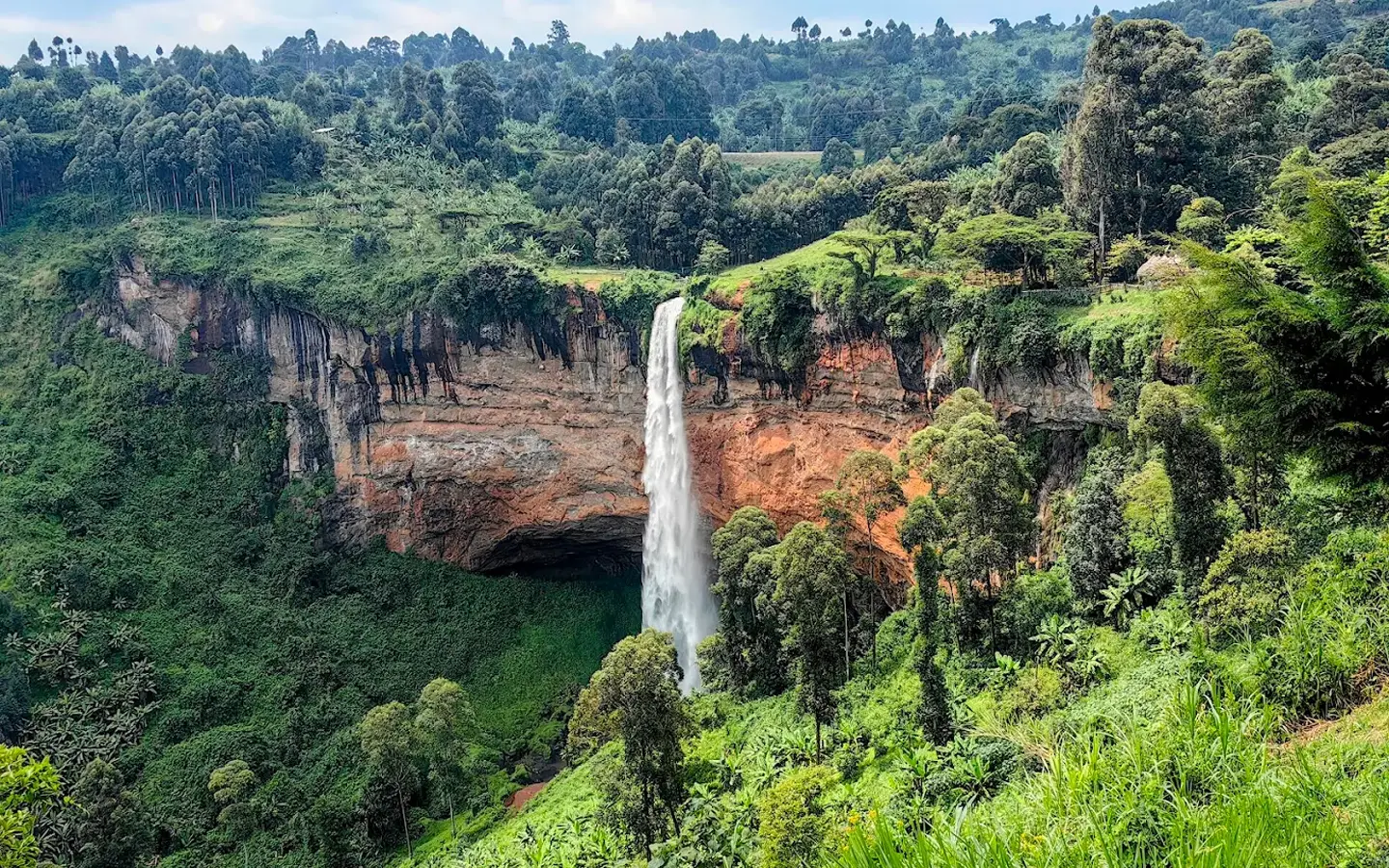
sipi falls
Tewei Hill
Tewei Hill rises above the Sipi area and gives broad views towards the waterfalls, Mount Elgon and the Karamoja plains. The hill is connected with Sabiny history and King Chemonges Kingo, who met his people here during the 1960s. Use Tewei Hill as a shorter outing from Sipi when you want an elevated viewpoint without entering the high mountain. Start early or walk later in the afternoon for cooler conditions and clearer light. Local access and the exact walking line are best arranged with a guide from the Sipi area.
Nyero Rock Paintings
The Nyero Rock Paintings lie in Kumi District, about 65 kilometres north of Mbale. Three main rock shelters contain geometric designs, concentric circles, canoe-like forms and other figures painted on the rock. The site is separate from Mount Elgon National Park but fits naturally into a longer eastern Uganda journey. Add Nyero when travelling between Mbale and destinations farther north or west. It requires its own road transfer and guided site visit, so allow enough time rather than treating it as a stop inside the park.
Endebess Bluff
Endebess Bluff lies inside Kenya’s Mount Elgon National Park. The trail leads through forest to a high viewpoint across the Kenyan side of the park, the plains around Kitale, and sections of the wider mountain. It works as a short day hike for visitors entering through Chorlim Gate. Do not combine it casually with a Ugandan Sipi itinerary. Reaching the bluff from Uganda requires a border crossing, Kenyan park entry, and a separate vehicle approach through Kitale or Endebess. For a short Ugandan walk, use the forest routes around Kapkwai instead.
Attractions Around the Wider Mount Elgon Region
The wider eastern Uganda circuit includes Pian Upe Wildlife Reserve, the Karamoja plains, Nyero Rock Paintings and the Wanale area above Mbale. These places add wildlife, cultural sites and lower-altitude scenery to a Mount Elgon journey. Pian Upe lies north of the mountain and supports ostriches, roan antelopes and other dry-country wildlife. Nyero adds ancient rock art, while Wanale provides cliff and valley views close to Mbale. Keep these as separate itinerary stops because they do not lie within Mount Elgon National Park.
Activities in Mount Elgon National Park
Walking defines the Mount Elgon experience. Multi-day treks lead to Wagagai and the caldera, while shorter guided walks explore the forest around Kapkwai. Birding, cave visits, camping, cycling and community experiences add variety on the lower slopes and in the neighbouring Sipi region.
Hiking and Multi-Day Trekking on Mount Elgon
Mount Elgon is a non-technical mountain, so the normal summit routes do not require ropes, ice axes or specialist climbing skills. Fitness, altitude, cold, rain and long walking days still make the trek demanding. The Sasa Trail reaches Wagagai and returns to Budadiri in 3 to 4 days. The Sipi route starts higher at Kapkwai and provides a longer, more gradual ascent. Piswa and Suam approach from the northern side. As the trail climbs, forest gives way to bamboo, giant heather and open moorland. Treks use designated camps, with guides and porters supporting the route. Cross-border traverses require advance immigration, park and route arrangements. Do not plan to walk across the international boundary without those clearances.
Short Forest Walks and Ranger-Guided Hikes
Kapkwai Forest Exploration Centre is the main base for shorter walks on the Ugandan side. Trails of different lengths pass through montane forest to caves, waterfalls, viewpoints and birding areas. These walks suit travellers who want Mount Elgon’s forest without committing to the summit. Allow several hours rather than rushing the route. A slower pace improves the chance of seeing colobus, blue monkeys, forest birds, orchids and butterflies. The trail can become slippery after rain, so wear shoes with firm grip and carry a light waterproof layer.
Bird Watching in Mount Elgon
Birding starts in the lower forest and continues into bamboo, heath and moorland. African blue flycatcher, African goshawk, cinnamon-chested bee-eater, Hartlaub’s turaco, Jackson’s francolin, Tacazze sunbird and black-collared apalis are among the key species. Early morning is productive around Kapkwai, river edges and forest clearings. On a summit trek, keep binoculars accessible instead of packing them deep inside a porter bag. Higher zones bring a different group of birds from the lower forest, so record sightings by altitude and habitat.
Cave Exploration
Guided forest walks on both sides of Mount Elgon reach volcanic caves. On the Kenyan side, Kitum, Making’eny, Chepnyalil and Ngwarisha form the main cave circuit. On the Ugandan side, walks around Kapkwai combine caves with waterfalls, forest and viewpoints. Caves are dark, damp and uneven. Carry a headlamp, wear shoes with grip and follow the guide’s route. Elephants and other wildlife use some Kenyan caves, so never enter without the required escort. Select the cave first, then book the correct national park and gate.
Mountain Biking Around Sipi and Kapchorwa
Mountain biking takes place on the lower slopes around Sipi and Kapchorwa rather than on the high summit trails. Routes use village roads, farm tracks and highland paths, with steep climbs and long descents. A short ride can take about 90 minutes, while half-day and full-day options cover more of the surrounding hills. Use a well-maintained mountain bike with working brakes and suitable tyres. A local guide helps with route choices, village junctions and changing trail conditions. Carry water, a helmet and rain protection because weather shifts quickly on the slopes.
Cultural Visits Around Mount Elgon
The Bagisu or Bamasaaba, Sabiny and Sabaot communities live around Mount Elgon. Bagisu families speak Lumasaba and maintain the Imbalu initiation ceremony, held in even-numbered years. Sabiny communities speak Sebei and have strong pastoral and farming traditions on the northern slopes. Community-led visits can include coffee farms, food preparation, local history, music and conversations about life on the mountain. Arrange the visit through an established local guide, ask before photographing people, and give the experience enough time to feel like a real exchange.
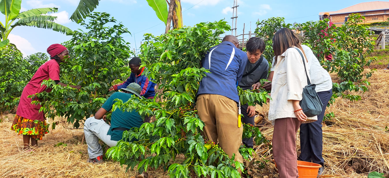
Sipi Falls Coffee Tours
Camping on Mount Elgon
Camping supports every multi-day summit route. Designated sites lie at different altitudes between the forest and upper moorland. Facilities are basic, and hikers sleep in tents rather than mountain huts on most Ugandan routes. Carry a warm sleeping bag, insulated mat, waterproof tent and dry storage for clothing. Temperatures drop sharply after sunset, and rain can reach the mountain in any month. Porters carry shared equipment according to the trekking arrangement, but confirm personal luggage limits before arrival.
Game Drives and Wildlife Walks
Mount Elgon is not a conventional game-drive park. The Ugandan side is explored mainly on foot because forest, steep slopes and trekking trails dominate the landscape. Guided walks provide the best chance of seeing monkeys, duikers, bushbuck and signs of larger mammals. Vehicle-based wildlife viewing is more relevant on the Kenyan side, where roads connect Chorlim Gate, cave areas, forest and viewpoints. Even there, walking, birding and cave exploration remain the main reasons to visit. Choose a savannah park if game drives are the central purpose of the safari.
Horse Riding on the Lower Slopes
Horse riding is available through selected operators around the lower slopes and on the Kenyan side. Routes follow open tracks and forest-edge areas rather than the Ugandan summit trail. Session length and rider requirements depend on the operator. Confirm the exact starting point before adding the activity to an itinerary. Sipi, Kapchorwa, Kitale and Chorlim are far enough apart that a general reference to “Mount Elgon” does not guarantee a convenient transfer.
Best Time to Visit Mount Elgon National Park
Mount Elgon can be climbed throughout the year, but the driest periods provide firmer trails and clearer views. The main dry seasons run from June to August and December to March. Rain can still fall at any time, and temperatures drop quickly above the forest line.
Visiting Mount Elgon During the Drier Months
Choose June to August or December to March for a summit trek. Forest paths, the Mudangi Cliffs and moorland sections are easier when rainfall is lower. Clear mornings also improve views across the caldera, Karamoja plains and western Kenya. December and January remain popular for holiday travel, so secure guides, porters and accommodation early. Carry waterproof clothing in every dry month because cloud, wind and rain develop quickly at higher altitude. September brings wildflowers but sits outside the main dry periods.
Visiting Mount Elgon During the Wetter Months
The wetter periods fall mainly from April to May and September to November. Trails become muddy, steep sections turn slippery, and cloud can reduce visibility around the summit. Trekking remains possible with extra time, strong footwear and reliable rain protection. These months bring greener forest, fuller waterfalls and flowering plants. Start walking early and keep daily distances realistic. A flexible itinerary helps when heavy rain slows the group or makes a high section unsafe to cross at the planned time.
How to Get to Mount Elgon National Park
The route depends on the side of the mountain and your trailhead. Mbale, Budadiri, Sipi and Kapchorwa serve the Ugandan side. Kitale and Chorlim Gate serve the Kenyan side. Confirm the route before leaving the main highway because local roads branch towards different entrances.
Getting to Mount Elgon National Park by Road
Mount Elgon lies about 235 kilometres east of Kampala. Drive through Jinja to Mbale, then continue according to the planned activity. Budadiri is the starting point for the Sasa Trail. Sipi and Kapkwai serve the Sipi route and lower forest walks, while Kapchorwa connects with northern approaches. Kampala to Mbale takes roughly 4 to 5 hours in normal traffic, followed by 1 to 2 hours to many trailheads. From Nairobi, drive about 420 kilometres to Kitale. The journey takes around 7 to 8 hours before stops. Kitale lies about 35 kilometres from Kenya’s Mount Elgon National Park. A signposted murram road leads through Endebess to Chorlim Gate and the park headquarters. A 4×4 becomes valuable during the rains and for roads beyond the main gate.
Getting to Mount Elgon National Park by Air
The Ugandan side has no scheduled passenger flight directly to the trailheads. Driving through Jinja and Mbale remains the clearest route from Kampala or Entebbe. Charter arrangements can be explored separately, but they still require a road transfer to the chosen starting point. For the Kenyan side, scheduled flights connect Nairobi with Eldoret and Kitale. Eldoret Airport is about 70 kilometres from the park, while Kitale Airstrip is about 30 kilometres away. Arrange a vehicle from the airport to Chorlim Gate or accommodation because neither airfield sits at a trekking trailhead.
Where to Stay at Mount Elgon National Park
Choose accommodation according to the side of the mountain and the trailhead. Kapkwai, Sipi, Budadiri and Mbale serve Ugandan treks. Koitoboss Guesthouse, Kapkuro Bandas, Kitale and campsites around Chorlim serve Kenya’s national park. Staying on the wrong side creates a long road transfer and, in some cases, an international border crossing.